SAR for Ship Detection
SAR for Ship Detection
Ship detection with satellite imagery in the commercial space is primarily focused towards resolving issues pertaining to the environment, commerce, and national security. Due to the possibility of the presence of thick cloud cover over oceanic landscapes and the requirement of day-night monitoring of marine traffic synthetic aperture radar (SAR) systems have been adopted for the purpose of surveillance. Performance of such systems has been commendable over the past decades with high-resolution wide-swath systems orbiting the Earth providing high spatial & temporal coverage. The problem of detecting ships is looked at either from a target/object detection perspective or by observing anomalies over the undulating waters, like smooth morphological trails resembling the wake of the ship. Over several decades, ship detection with SAR was constrained by the availability of single-channel datasets that provided limited partial insights into the polarimetric scattering behaviour of the target.
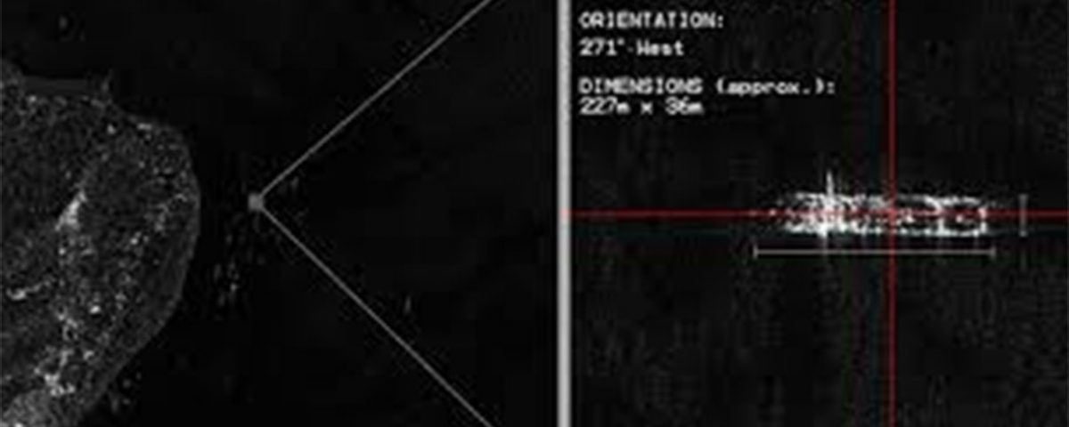
The inception of full-polarimetric systems has revolutionized the domain of SAR imaging by filling the information gap of the single-channel systems. Such systems exploit various polarization combinations to optimize ship detection applications. The availability of the cross-polarized channel information along with the co-polarized signatures offers a unique opportunity to locate the ship in the form of a distinctive point target against the dark cluttered backdrop. SAR systems enjoy an unparalleled authority in this domain due to the system’s sensitivity to geometrical structures. Ships can essentially be modelled as a block of metal floating over the ocean surface with its walls intersections acting as dihedral/trihedral corner reflectors. By virtue of this such targets can be clearly distinguished from its grainy speckled surrounding occurring due to ripples prevailing over the surface of the ocean. Certain space agencies enable the user to define the imaging mode wherein the data can be acquired in a particular imaging mode that basically defines the spatial coverage, resolution, and noise floor. These modes establish a balance between the spatial coverage and resolution of a scene. In the state-of-the-art satellites like RADARSAT-2 operated by the Canadian Space Agency (CSA), Wide-Swath mode provides increased spatial coverage without loss of resolution while Spotlight mode provides high spatial resolution. For high confidence vessel detection with low false alarm rate high-resolution images are desired, typically of the order of 5m. Finer resolution images of the order of 1 m in the Spotlight mode are offered by the German space agency’s TerraSAR-X spaceborne platform. Moreover, the distance of the Region of Interest (ROI) under surveillance off the coast and the vessel size defines the choice of the resolution. For coastal & shelf areas where smaller vessels are of interest high resolution is preferred while ROIs located beyond 300-400 off the coast can be observed with relatively coarser resolutions due to the extreme scales of the vessels prevalent in such waters.
Maritime surveillance acts towards monitoring the traffic approaching the coastal waters, curbing illegal fishing, and keeping a check on suspicious vessels. Conventionally, this task is executed by the Vessel Traffic Services (VTS), which is the marine counterpart of Air Traffic Control (ATC), who monitors Automated Identification System (AIS) signals broadcasted by the VHF transponders installed in vessels. Law for vessels governed by the International Maritime Organization (IMO) mandates the presence of an AIS module, which conveys its unique identity to its neighbours and port authorities from as far as 40 km off the coast. For vessels bound off the coast, Satellite AIS (SatAIS) as a space-borne platform assures global coverage. Non-compliance of such stringent norms indicates possible illegal intentions, which demands prompt actions to avoid a catastrophic state. This is a typical scenario where SAR images function in conjunction with AIS signals to identify & cross-correlate ships and eventually isolates the defaulting vessels observed in the satellite scene, which would have otherwise passed undetected.